

The Firemap platform leverages real-time information on weather conditions and fire ignitions to monitor and predict direction and speed of fire spread, as well as communities at risk. Through a partnership with California’s Fire Integrated Real-time Intelligence System (FIRIS), the tool has revolutionized initial attack response across California through a process that provides maps and models within minutes of ignition, which can then be updated to include sensed data from aircrafts for the most dangerous fires. Firemap also supports a similar fire resource network in Colorado.

BurnPro3D is a web-based platform to help the fire management community understand risks and tradeoffs when planning and conducting prescribed burns. The interface allows burn planners to create and visualize high-resolution 3D fire simulations and compare fuel consumption and risk under different weather and ignition scenarios. It uses the 3D FastFuels vegetation model developed by the U.S. Forest Service and the QUIC-Fire coupled fire/atmosphere model developed by Los Alamos National Lab.

WIFIRE Edge is a middleware solution that makes disparate edge sensing and computing products accessible through a unified web service interface. The integrated edge products include Redline Safety sensors, SAGE nodes funded by the National Science Foundation, and N5 sensors deployed by the Department of Homeland Security. Currently, FIREMAP, BurnPro3D and ATAK uses WIFIRE Edge to integrate real-time edge products into specialized platforms.
WXmap is an integrated weather data tool for fire risk prediction that provides web-based visualizations of twelve weather forecast models twice a day from San Diego Gas & Electric (SDG&E) and two models from NOAA. The SDG&E weather models include several forecast variables related to wildfires such as Dead Fuel Moisture, Energy Release Component (ERC) and Large Fire Potential.
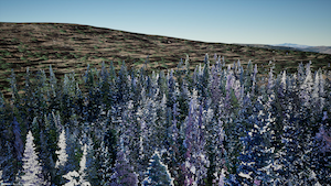
Points2Pano is a tool that was developed as part of our Immersive Forest project. It leverages terrestrial lidar scans from the Interagency Ecosystem LiDAR Monitoring (IntELiMon) collaboration to provide a visualization of the data alongside metrics and analyses derived from the data. The tool was built to support practitioners in ecosystem monitoring efforts.
Data and Model Services: We work closely with our partners to provide intelligent and integrated infrastructure to catalog, curate, exchange, analyze, optimize, and communicate their big data and models at scale. These services are grounded in FAIR principles — making data and models Findable, Accessible, Interoperable, and Reusable — to ensure they are not only powerful but usable, shareable, and enduring.